
Tucson Water
One Water 2100 Master Plan
Technical Memorandum
LAND USE PLANNING
FINAL | February 2022

Tucson Water
One Water 2100 Master Plan
Technical Memorandum
LAND USE PLANNING
This document is released for the
purpose of information exchange review
and planning only under the authority of
Fair Yeager, February 2022, Arizona PE
35903.

LAND USE PLANNING | ONE WATER 2100 MASTER PLAN | TUCSON WATER
FINAL | FEBRUARY 2022 | i
Contents
Technical Memorandum 1
1.0 Introduction 1
2.0 Planning Area 1
3.0 Land Use Planning Considerations 3
3.1 City of Tucson 3
3.2 Pima County 5
3.3 Town of Oro Valley 6
3.4 Town of Marana 8
3.5 City of South Tucson 8
3.6 Pascua Yaqui Tribe Reservation and Trust Lands 9
4.0 State Land 9
5.0 Regional Transportation Planning 11
5.1 Interstate Highway 11 11
5.2 Sonoran Corridor 14
6.0 Conclusion 15
Figures
Figure 1 Tucson Water Service Area 2
Figure 2 City of Tucson Future Growth Scenario Map 4
Figure 3 Pima County Focused Development Investment Areas 5
Figure 4 Oro Valley’s Historic and Projected Water Use by Source of Supply 7
Figure 5 State Land Holdings near Houghton and Valencia Roads 10
Figure 6 I-11 Corridor Alternatives 12
Figure 7 I-11 Recommended Alternative 13
Figure 8 Sonoran Corridor Alternatives 14

LAND USE PLANNING | ONE WATER 2100 MASTER PLAN | TUCSON WATER
FINAL | FEBRUARY 2022 | ii
Abbreviations
ADOT Arizona Department of Transportation
af/yr acre-feet per year
CAP Central Arizona Project
EIS Environmental Impact Statement
FHWA Federal Highway Administration
HAMP Houghton Area Master Plan
I-10 Interstate Highway 10
I-11 Interstate Highway 11
IGA Intergovernmental Agreement
NWRRDS Northwest Recharge, Recovery, and Delivery System
PAG Pima Association of Governments
PCD Planned Community Development

LAND USE PLANNING | ONE WATER 2100 MASTER PLAN | TUCSON WATER
FINAL | FEBRUARY 2022| 1
Technical Memorandum
LAND USE PLANNING
1.0 Introduction
On August 4, 2010, the Mayor and Council adopted a Water Service Area Policy
1
for Tucson Water that
established a long-range planning area for the utility. It includes existing and potential future service areas,
and areas where the utility has no plans to provide direct service. Water service is different from most City
services in that water service is provided in areas outside the City of Tucson boundaries. The Water Service
Area is further discussed in Section 2 below.
Although the utility has no plans to serve areas outside its service area, it works with other water providers
on water supply and service matters of mutual benefit. For example, Tucson Water wheels (conveys) other
providers’ water to them and provides emergency interconnects to other water providers and vice-versa.
Consequently, for Tucson Water’s long-range planning purposes, it is important to consider where and how
much growth may occur not only within the City of Tucson but in neighboring jurisdictions as well, including:
• Town of Marana
• Town of Oro Valley
• Pascua Yaqui Tribe Reservation and Trust Lands
• Unincorporated Pima County
• City of South Tucson
This memorandum summarizes where projected growth and development may occur by confirming
adopted planning efforts and identifying development trends and new planning considerations in these
areas. Land use planning impacts associated with regional transportation planning and potential releases of
State Land are also discussed.
2.0 Planning Area
As noted, the City of Tucson established the utility’s Water Service Area boundary in 2010 with the adoption
of a formal Water Service Area Policy. The map on Figure 1 illustrates the extent of the current obligated
Water Service Area, as well as potential areas of water service expansion, and non-expansion areas. The
obligated service area includes areas within the City limits or contracted service areas that Tucson Water will
serve in the future. The map is not intended to provide parcel-level guidance on water service availability,
but rather meant to provide a general overview of Tucson Water’s service in the region. All parcels within the
City limits are eligible for water service. New requests for water service outside of the existing obligated
1
City of Tucson, 2010, 2011 and 2013. “Resolution No. 21602” and subsequent amendments “Resolution No.
21753” and “Resolution No. 22080.” Accessed July 25, 2019.
https://www.tucsonaz.gov/files/water/docs/Resolution_21602.pdf
.

LAND USE PLANNING | ONE WATER 2100 MASTER PLAN | TUCSON WATER
FINAL | FEBRUARY 2022| 2
Water Service Area require a water availability request, and staff review of the specific parcel(s) in question.
The obligated Water Service Area may also be modified through approved City of Tucson annexations or by
direction of the Mayor and Council.
The current Water Service Area spans several jurisdictions, with about 42% of the geographic area lying
within the City of Tucson and nearly 53% in unincorporated Pima County. Marana (4%), Oro Valley (1%),
South Tucson and Pascua Yaqui lands (less than 1% each) round out the Water Service Area. The Town of
Oro Valley is also a wholesale customer of Tucson Water, and other potable wheeling agreements are in
place with Metro Water District, Vail Water, and the Pascua Yaqui Tribe. The utility wheels reclaimed water
to the Town of Oro Valley, Metro Water District, Pima County, and other smaller water providers.
Figure 1 Tucson Water Service Area

LAND USE PLANNING | ONE WATER 2100 MASTER PLAN | TUCSON WATER
FINAL | FEBRUARY 2022| 3
3.0 Land Use Planning Considerations
3.1 City of Tucson
The City’s current General & Sustainability Plan, Plan Tucson, was approved by voters and adopted by the
Mayor and Council in 2013.
2
As shown on Figure 2, anticipated growth areas include the downtown core and
major transportation corridors as the City pursues a strategy of transit-oriented development.
Extensive growth is expected in the Houghton Road corridor in southeastern Tucson. Planning and
Development Services staff expect the area to develop over the next decade, with construction of about
5,000 housing units expected within master planned communities. Anticipated trends in the area include
increased residential densities and more multifamily units, including townhomes.
Citywide, in addition to new single and multifamily housing units, the expanded construction of group
quarters (e.g., student housing) is anticipated. Rezoning is expected at the northwest corner of Campbell
Avenue and Speedway Boulevard for development of a 20-story residential building with ground floor retail.
Non-residential and residential infill development and redevelopment in the downtown area has been
vertical in nature, where multi-story buildings are becoming more common. Non-residential development is
occurring near the Tucson International Airport, where industrial uses, such as logistics and defense, are
prevalent. The University of Arizona Tech Park at Rita Road has expressed interest in expanding within the
obligated Service Area, which entails mixed-use development including retail, commercial, and residential
uses along with a hotel. Although this area is currently supplied by private groundwater wells, future
development may require additional water service from Tucson Water. Investors have also expressed
interest in developing several hundred thousand square feet of medical marijuana greenhouses along
Interstate Highway 10 (I-10) in the southern part of the City.
Additional anticipated projects or trends include:
• Residential redevelopment in the vicinity of Park Place Mall.
• Conversion of excess and unused commercial properties (i.e., “big box” retail spaces) to other uses
such as entertainment or fitness centers.
• Redevelopment of the Grant Road corridor as roadway reconstruction is completed.
• Redevelopment potential of the northwest and southwest corners of the Oracle Road / River Road
intersection.
• Conversion of closed and now vacant Tucson Unified School District sites to other uses including
housing. For example, the Corbett Elementary School site on 29
th
Street west of Wilmot Road is
planned for housing (eight to ten housing units per acre), and the Julia Keen Elementary School site
on Ellington Place and Palo Verde Avenue was converted to a community garden.
• Strong growth and redevelopment along the Speedway Boulevard corridor, although zoning issues
may be a hurdle for development in this area.
• Infill growth along Broadway Boulevard from Euclid Avenue to Country Club Road after roadway
expansion is completed that will double the intensity of current uses.
• Potential development of lands immediately east of I-10 and south of Grant Road by the Pascua
Yaqui Tribe.
2
City of Tucson. 2013. Plan Tucson: City of Tucson General & Sustainability Plan 2013.
https://www.tucsonaz.gov/pdsd/plan-tucson
.

LAND USE PLANNING | ONE WATER 2100 MASTER PLAN | TUCSON WATER
FINAL | FEBRUARY 2022| 4
Source: Plan Tucson, November 2013.
Figure 2 City of Tucson Future Growth Scenario Map

LAND USE PLANNING | ONE WATER 2100 MASTER PLAN | TUCSON WATER
FINAL | FEBRUARY 2022| 5
In addition to development and redevelopment within City limits, growth in potential annexation areas must
be considered. The City relies upon Plan Tucson and the Water Service Area Policy for guidance relative to
potential annexations. Areas planned for annexation in the near-term include the following:
• Valencia Road and Kolb Road area: logistics and other non-residential uses are planned
• State Land, bounded by Valencia Road, Swan Road, Alvernon Way and Los Reales Road: residential
development is planned with supporting commercial uses
3.2 Pima County
Pima County’s current Comprehensive Plan, Pima Prospers, identifies three growth areas
3
as illustrated in
orange on Figure 3:
• Flowing Wells Focused Development Investment Area
• Southwest Focused Development Investment Area
• Tucson International Airport/I-10 Economic Development Area
Figure 3 Pima County Focused Development Investment Areas
Less than half of the Flowing Wells growth area is within the Tucson Water Service Area. The County expects
redevelopment in this area, and infill is occurring as well. The County has recently reduced parking
3
Pima County. 2015. Pima Prospers: Comprehensive Plan. http://webcms.pima.gov/government/pima_prospers/

LAND USE PLANNING | ONE WATER 2100 MASTER PLAN | TUCSON WATER
FINAL | FEBRUARY 2022| 6
requirements for non-residential developments, which may increase the potential for infill by encouraging
the redevelopment of former parking areas.
In the Southwest growth area, only the Star Valley subdivision lies within the Tucson Water Service Area.
Star Valley’s County-approved Specific Plan calls for about 7,000 residential units in addition to supporting
commercial development and public uses. Approximately 10% of the residential units will be multifamily,
and much of the remaining residential units will be low density (five housing units per acre). There are about
1,600 existing customers within this area.
More than half of the Tucson International Airport/I-10 growth area is within the Tucson Water obligated
Service Area, and additional portions of the growth area are designated as potential expansion areas. The
County anticipates primarily non-residential development in this region. In particular, logistics uses are
expected near the airport. Commercial development is expected in the vicinity of Pima County Fairgrounds
as County wastewater service is extended into the area.
Development of the South Kolb property in the Airport/I-10 growth area will be guided by an approved
Specific Plan and Amendment. The property, located near Davis-Monthan Air Force Base east of Kolb Road
and south of Valencia Road, will support commercial and industrial uses. A portion of this property is within
Tucson Water’s obligated Service Area, and the remainder is within the potential expansion area. City of
Tucson annexation of the area is anticipated.
Other County areas within the Tucson Water obligated Service Area where growth is expected include the
Santa Rita Ranch and Santa Rita Mountain Ranch subdivisions. These areas are near Houghton Road and
Sahuarita Road, and each development has an approved Specific Plan. Santa Rita Ranch on the east side of
Houghton Road is planned for about 6,100 housing units; there are approximately 1,020 existing customers.
Santa Rita Mountain Ranch on the west side of Houghton Road is planned for 1,320 housing units, with
roughly 600 current customers in the area.
3.3 Town of Oro Valley
The Town of Oro Valley owns and operates its own water utility, but it also receives water from Tucson
Water. Oro Valley receives about 2,100 acre-feet per year (af/yr) of recovered Central Arizona Project (CAP)
water that Tucson Water wheels through its distribution system to several connection points in the town.
Oro Valley also pays for the delivery of reclaimed water from Tucson Water to support its reclaimed water
system and customers.
Oro Valley completed its General Plan update in 2016. More recently, the Oro Valley has been collaborating
with Pima Association of Governments (PAG) to update its population projections. Oro Valley is now
expecting to reach buildout no later than 2030 as shown on Figure 4.

LAND USE PLANNING | ONE WATER 2100 MASTER PLAN | TUCSON WATER
FINAL | FEBRUARY 2022| 7
Source: Peter Abraham, Town of Oro Valley, email message forwarded to author, August 14, 2019.
Figure 4 Oro Valley’s Historic and Projected Water Use by Source of Supply
Oro Valley expects to continue utilizing its CAP wheeling agreement with Tucson Water and may increase its
annual wheeling capacity to approximately 2,600 af/yr per the agreement. Oro Valley is jointly working with
Marana and Metro Water District on the Northwest Recharge, Recovery, and Delivery System (NWRRDS).
This large-scale capital project will deliver an additional 4,000 af/yr of Oro Valley’s CAP allotment by 2024.
With respect to reclaimed water use, Oro Valley is making full use of its entitlement and is not planning to
expand its reclaimed water system.
Much of Oro Valley’s recent growth is due to single-family residential development in neighborhoods along
La Cholla Boulevard, with smaller lots of about 6,000 to 8,000 square feet. Although some multifamily
housing is planned along the Oracle Road corridor, the current political climate in Oro Valley is not favorable
to this type of development. Overall, Oro Valley is expecting about 2,300 to 2,800 more single-family units
to reach build out.
Oro Valley is promoting job growth with non-residential development, and such growth is expected in the
commercial area north of Tangerine Road on Innovation Park Drive as well as along Oracle Road. In general,
non-residential development has been limited to two- or three-story buildings, and this trend is expected to
continue. Like other parts of the greater Tucson area, Oro Valley has been experiencing long-term vacancies
of former big box stores, and planners are considering mixed-use redevelopment of these parcels.
Oro Valley is also considering annexing an 880-acre State Land parcel in unincorporated Pima County on
Tangerine Road. However, other entities are also interested in this land, and ownership has not yet been

LAND USE PLANNING | ONE WATER 2100 MASTER PLAN | TUCSON WATER
FINAL | FEBRUARY 2022| 8
determined. If Oro Valley is successful in annexing the parcel, it would likely be developed into 6,000 to
8,000 square-foot residential lots.
3.4 Town of Marana
Marana owns and operates its own water and wastewater utilities, but much of the existing service area is
concentrated in the land area west of I-10 and does not included the entire Town of Marana limits. Other
water providers also serve customers in Marana; of these, the Tucson Water Service Area is the largest
encompassing just less than 20% of the Town of Marana’s land area.
The Town of Marana is currently updating its General Plan and expects to complete it prior to the end of
2019. The largest development in Marana within Tucson Water’s long-range planning area is Dove
Mountain. While the approved Specific Plan projected over 9,100 housing units, the area is not developing to
that density level. Roughly 5,600 housing units have been platted, and about 4,600 of those have been
developed to date. Marana anticipates about 1,200 more homes will be developed in this area, bringing the
total to about 5,800 housing units. In addition, a 35-acre parcel on the northwest corner of Dove Mountain
Boulevard and Twin Peaks Road is currently used for parking but is expected to be developed with large-
scale commercial uses.
Just east of Dove Mountain, the Saguaro Ranch subdivision is developing at lower densities than originally
planned. About 90 housing units are permitted in this area. To the south, the Tapestry subdivision is
primarily planned for medium density residential uses. This subdivision is approved for about 850 housing
units with just under 200 units in the platting process. It may also include a resort.
On Silverbell Road north of Ina Road, a commercial development called Marana Gateway is planned.
Although a conditional use permit would allow a building up to 90 feet in height, the Town of Marana
anticipates it would not be permitted for more than four stories.
Marana is also expecting multifamily development near this project just south of Crossroads Park. While this
area is not within Tucson Water’s planning area, the Town of Marana may seek service in the form of
wheeling from the City. Another multifamily project planned within the Tucson Water Service Area is along
Aerie Drive between Ina Road and Thornydale Road. This project may include a few hundred units.
Other areas planned for development include:
• Parcels near the movie theater along Arizona Pavilions Drive and Cortaro Road.
• Expansion of a medical marijuana facility on Ina Road, including 240,000 square feet of greenhouses
and 10,000 square feet of office space.
3.5 City of South Tucson
The City of South Tucson is a small community of about one square mile that is surrounded by the City of
Tucson and is fully served by and completely within the Tucson Water Service Area. It is just south of
downtown Tucson and is east and north of I-10 and the I-10/I-19 junction. About half of the developable area
is zoned for residential uses, about 40% is zoned for commercial uses, and the remaining area is zoned for
industrial uses. A large majority of the housing stock consists of rental units with an estimated occupancy
rate of approximately 90%.
South Tucson expects redevelopment of the residential corridor along 5
th
Avenue from the northern city
limit to 36
th
Street with increased densities and potential for multifamily projects. The multifamily
developments may reach three stories in height.

LAND USE PLANNING | ONE WATER 2100 MASTER PLAN | TUCSON WATER
FINAL | FEBRUARY 2022| 9
The southeast area of South Tucson includes undeveloped and underused parcels, where commercial and
retail uses may ultimately replace industrial uses. Along the City’s eastern boundary, City staff expects the
former El Paso and Southwestern railroad right-of-way to transition to a “greenway” corridor with native
plants.
3.6 Pascua Yaqui Tribe Reservation and Trust Lands
The Pascua Yaqui Tribe Reservation is located southwest of downtown Tucson, west of the I-19 and south of
Ajo Highway. The City entered into a water service agreement
4
with the Pascua Yaqui Tribe in 2011 that
included:
• Wheeling the Tribe’s CAP allocation through City CAP storage facilities and back to the Tribe
• Storage of the Tribe’s CAP allocation and other water in City underground storage facilities
• Purchase of CAP long term storage credits
The City also delivers potable water to approximately 600 residential and commercial customers located on
the Pascua Yaqui Reservation.
In September 2019, the City’s Mayor and Council approved an intergovernmental agreement (IGA) with the
Tribe.
5
The IGA places just over 14 acres of Tribe-owned land within the City near the southeast intersection
of the I-10 and Grant Road in trust. The Tribe has jurisdictional oversight of the land with this designation.
The Tribe’s plans to redevelop the parcel have not been finalized although there is potential to construct a
gaming facility. The IGA permits Tucson Water to provide potable water service if the building or project
meets the City’s rainwater or greywater harvesting standards and if it is not developed as a gaming facility;
the Tribe would need to provide water from its own resources if a gaming facility is ultimately developed.
4.0 State Land
The Arizona State Land Department (State Land) holds title to over 9,000,000 acres of land throughout the
state. It may lease or sell the land for the benefit of the state’s public schools. In the last several years, State
Land has sold about 5,000 acres per year on average.
6
There are large tracts of State Land within the Tucson
Water Service Area, and a few are planned to be released for development within the planning horizon of
this Master Plan update.
Several State Land parcels near the intersection of Houghton and Valencia Roads could be released and
developed in about 20 to 30 years, per State Land staff. This area is located within the City’s adopted
Houghton Area Master Plan
7
(HAMP) area, and land use guidance is provided by that plan. When parcels are
rezoned, greater land use planning definition is provided, which may include changes to the HAMP
conceptual land use map. When the HAMP was developed, such changes were envisioned provided they
adhered to the underlying HAMP planning framework.
A roughly 360-acre site at the southwest corner of this intersection (yellow polygon on Figure 5) is planned
for four housing units per acre in the southwestern portion, and for eight to 15 housing units per acre plus
4
City of Tucson, 2011. “Resolution No. 21691.” Accessed November 8, 2019.
5
City of Tucson, 2019. “Resolution No. 23085.” Accessed November 5, 2019.
6
Arizona State Land Department, Accessed August 7, 2019. https://land.az.gov/about
7
City of Tucson, Houghton Area Master Plan, Adopted June 7, 2005. Accessed October 22, 2019.
https://www.tucsonaz.gov/files/pdsd/pdfs/HAMP-FULL.pdf

LAND USE PLANNING | ONE WATER 2100 MASTER PLAN | TUCSON WATER
FINAL | FEBRUARY 2022| 10
supporting commercial uses in the northeastern portion of the site. In all, approximately 3,000 housing units
may be developed in this area.
The northwest, northeast, and southeast areas of the Houghton Road and Valencia Road intersection
(orange area on Figure 5) encompasses roughly 1,700 acres. This area is part of a proposed Planned
Community Development (PCD) that includes a mix of low-density residential (majority of the use),
medium- and high-density residential, and supporting commercial uses near the arterial roadways. The
proposed PCD land use plan includes a Town Center that has been largely shifted from the northeast to the
northwest of the Houghton Road/Valencia Road intersection.
Figure 5 State Land Holdings near Houghton and Valencia Roads
Other areas of State Land that are actively being rezoned or are under consideration for near-term sale
include:
• Approximately 880 acres east of Thornydale Road spanning north and south of Tangerine Road as
described in Section 3.3; however, this area in not within the Tucson Water Service Area.
• Approximately 1,500 acres north of I-10 near East Mary Ann Cleveland Way.
• Approximately 480 acres bounded by Valencia, Swan, Alvernon and Los Reales Roads that would
require annexation by the City of Tucson. This may develop at six housing units per acre with

LAND USE PLANNING | ONE WATER 2100 MASTER PLAN | TUCSON WATER
FINAL | FEBRUARY 2022| 11
supporting commercial uses on Valencia Road. The City is progressing with annexation of this area
as previously noted.
• 86 acres east of Kolb Road near Irvington Road that are expected to be developed as low- and
medium-density residential.
5.0 Regional Transportation Planning
5.1 Interstate Highway 11
Interstate Highway 11 (I-11) is a north-south freeway that is being planned from Nogales to Wickenburg, AZ.
It is part of a series of freeway and other transportation infrastructure improvements in the western U.S.,
known as the CANAMEX corridor, that will connect Canada and Mexico. As part of the planning process, the
Federal Highway Administration (FHWA) and Arizona Department of Transportation (ADOT) published a
Draft Tier 1 Environmental Impact Statement (EIS) in March of 2019. The EIS identifies three alternative
alignments and a Recommended Alternative as shown in Figures 6 and 7.
8
8
Federal Highway Administration and Arizona Department of Transportation. 2019. Interstate 11 Corridor Draft
Tier 1 Environmental Impact Statement and Preliminary Section 4(f) Evaluation.
http://i11study.com/Arizona/Documents.asp
.
LAND USE PLANNING | ONE WATER 2100 MASTER PLAN | TUCSON WATER
FINAL | FEBRUARY 2022| 12
Source: Interstate 11 Corridor Draft Tier 1 Environmental Impact Statement and Preliminary Section 4(f) Evaluation, March 2019.
Figure 6 I-11 Corridor Alternatives

LAND USE PLANNING | ONE WATER 2100 MASTER PLAN | TUCSON WATER
FINAL | FEBRUARY 2022| 13
Source: Interstate 11 Corridor Draft Tier 1 Environmental Impact Statement and Preliminary Section 4(f) Evaluation, March 2019.
Figure 7 I-11 Recommended Alternative

LAND USE PLANNING | ONE WATER 2100 MASTER PLAN | TUCSON WATER
FINAL | FEBRUARY 2022| 14
The Recommended Alternative travels through Avra Valley west of Tucson, where Tucson Water has large-
scale operational recharge and recovery facilities. The Tucson City Council has opposed the Recommended
Alternative for environmental and economic reasons.
9
A Final Tier 1 EIS addressing comments and questions
is expected to be available in 2020. If the project progresses as planned, construction in the Tucson area may
not occur until 2040 or later. There is potential to construct a regional roadway prior to this timeframe,
which may occur within the next 10 to 20 years.
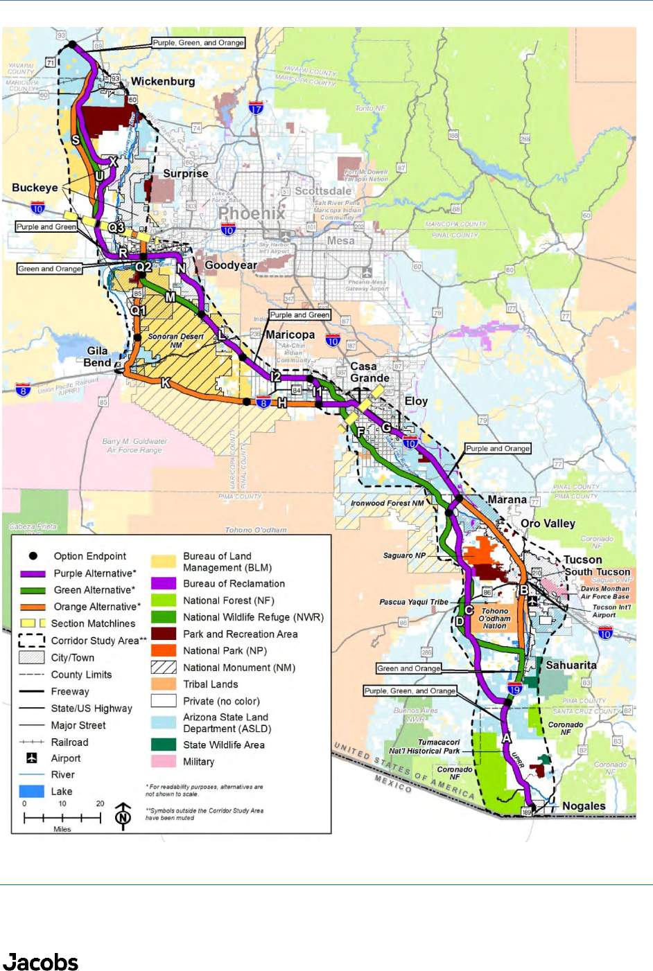
5.2 Sonoran Corridor
ADOT has completed a study of alternatives
10
for the Sonoran Corridor, which is planned to connect I-19 and
I-10 south of the Tucson International Airport. The project is intended to provide access to existing and
future employment centers, and three alternatives are being considered, as shown on Figure 8. In northern
parts of the corridor area, non-residential development is expected; while in the southern parts, residential
development may occur in and near Sahuarita. The southern study area is also near the Pima Mine Road
Recharge Facility.
Source: ADOT Corridor Selection Report, June 2019.
Figure 8 Sonoran Corridor Alternatives
9
Craig Smith, “Tucson City Council joins I-11 Opposition,” June 20, 2019, https://www.kgun9.com/news/local-
news/tucson-city-council-joins-i-11-oppositio.
10
Arizona Department of Transportation. 2019. Sonoran Corridor Tier 1 Environmental Impact Statement: Corridor
Selection Report.
https://azdot.gov/docs/default-source/transportation-studies/sonoran-corridor-selection-
report.pdf?sfvrsn=2.

LAND USE PLANNING | ONE WATER 2100 MASTER PLAN | TUCSON WATER
FINAL | FEBRUARY 2022| 15
ADOT expects to select an alternative in 2020, and a project specific environmental study would follow.
These efforts can span up to a decade; therefore, project implementation is not likely to occur for about
12 to 15 years depending on availability of funding. Portions of this corridor will pass through the Tucson
Water Service Area.
6.0 Conclusion
Within the Tucson Water Service Area, growth will occur as infill development and redevelopment in the
mostly built-out areas, and as larger-scale new growth in primarily undeveloped or underdeveloped areas. In
the mostly built-out areas, infrastructure maintenance and upgrades are key planning considerations. In new
growth areas, water demand, infrastructure upgrades, and new infrastructure must be considered. As per
adopted long-range land use plans, new growth is expected in the following areas:
• Buildout of the Dove Mountain subdivisions and surrounding areas in Marana with supporting
commercial development;
• Development of master planned residential communities with supporting commercial uses along
the Houghton Road corridor in the southeastern portion of the City;
• Expansion of non-residential development south of Tucson International Airport along the planned
Sonoran Corridor and around the Pima County Fairgrounds; and
• Non-residential development along the 1-10 corridor from Kino Parkway to Rita Road.
Tucson Water will continue to coordinate with local jurisdictions and water providers, as well as regional
planning agencies, and will monitor growth and development trends that may impact its systems and
operations.
